Design #1
The first design called for a system of swales and berms to deal with the stormwater runoff. It was presented to the council in 2019. During the discussions, there were a couple of interesting exchanges.
Councilmember Bentley asked if any existing lots drained into an area that will be paved over by the road. The presenter replied that all the houses along the road, both on the Doherty Extension and the Heritage Oaks Extension, drain from back to front; i.e., into the interior of the respective subdivision. This implied that the road would not impact drainage from the lots, but it is not correct. For the lots on the Heritage Oaks Extension, the lots drain in both directions. The incorrect statement played down the risk that the road would induce flooding, and misled the council about the complexity of the design.
Here is the audio.
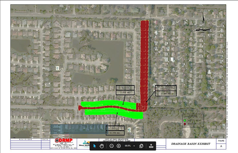
The drawing below shows the actual lot drainage. The green areas indicate drainage from the yards to the wooded area which will be paved over. The drawing verifies that, contrary to statements made to the city council, parts of the lots along the east-west segment of the road currently drain into the area which will be paved. (Note: Though required by the permit instructions, the city omitted this drawing in the original permit application; it was submitted only after SJRWMD specifically requested it.)
Later in the discussion, Councilmember Young asked about the specific route of the stormwater after leaving the Heritage Oaks area. The answer was that the water would be injected into the canal which runs south of Hollywood Estates, eventually reaching Crane Creek. Mayor Rose followed up with a question about whether or not the capacity of the canal would be expanded, and was told it would not.
The point of this line of questioning seemed to be that during a major storm, the new road would result in a massive amount of additional water which would be funneled out of the Heritage Oaks area, and possibly become a threat to Eastwood Two, Cannova Park, Clifton Edge, Deangellis Park, and Hollywood Estates,
etc. The image below shows the approximate location where the new water would be injected, and the subdivisions lying downstream from that point.
(Note: Canal is shown larger than actual for clarity.)
After further discussion, the city was authorized to proceed with the design effort based on the swales and berm concept.
SOIL TESTING
The design process required testing of the soil along the path of the road. When soil testing was done, it was found that the swale design would not work. Test results showed that, on the Heritage Oaks Boulevard Extension, the soil type was inadequate to support effective swale performance, and the water table level was too high. On the Doherty Drive Extension, there was insufficient space for swales within the right of way.
Since Design #1 was not viable, the city proceeded to Design #2, discussed on the next page.

