Stormwater Management
BACKGROUND
As shown on the previous page, very large rainfalls – even "500-year rain events" – are now quite common. However, the state requirements are obsolete, being based on the smaller, 25-year rain event. Designing to the minimum state requirement will leave us vulnerable.
Even without the road, residents have experienced area flooding which would have inundated their homes, if it had been an inch or so higher. Therefore, they believe that in a future hurricane, the additional water due to the new impervious road surface could trigger serious home flooding.
This has been discussed at several council meetings. During a discussion in 2018, city officials admitted that after Hurricane Irma:
-
The canal east of The Preserve (where the city wants to dump the stormwater that lands on the new road) was cresting
-
The walking path adjacent to the canal was also flooded
-
We have experienced two storms recently that exceeded the 25-year storm by a wide margin
-
After installation of the new road, storms of this magnitude could trigger additional widespread flooding.
In the words of the project manager for the road: " … if we get 150-year storms like we've been experiencing now and again, then the water is going to go to where it tries to go just naturally".
After further discussion, it was agreed that before beginning the road design, the city would undertake a preliminary design of a stormwater system to verify the road could be built without increasing the flood risk.
PRELIMINARY DESIGN
The new concept was presented to the council by the DRMP engineer in 2019. During the discussions, there were a couple of interesting exchanges.
Councilmember Bentley asked if any existing lots drained into an area that will be paved over. The engineer replied that all the houses along the road, both on the Doherty Extension and the Heritage Oaks Extension, drain from back to front; i.e., into the interior of the respective subdivision. This implied that the road would not impact drainage from the lots, but it is not correct. For the lots on the Heritage Oaks Extension, each lot drains in both directions. The incorrect statement played down the risk that the road would induce flooding, and misled the council about the complexity of the design.
Here is the audio.
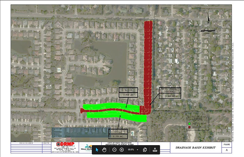
The drawing below shows the lot drainage. The green areas indicate drainage from the yards to the wooded area which will be paved over. The drawing verifies that, contrary to statements made to the city council, parts of the lots along the east-west segment of the road currently drain into the area which will be paved. (Note: Though required by the manual, this drawing was omitted from the original permit application; it was submitted only after SJRWMD specifically requested it and cited the requirement.)
Later in the discussion, Councilmember Young asked about the specific route of the stormwater after leaving the Heritage Oaks area. The answer was that the water would be injected into the canal which runs south of Hollywood Estates, eventually reaching Crane Creek. Mayor Rose followed up with a question about whether or not the capacity of the canal would be expanded, and was told it would not.
The point of this line of questioning seemed to be that during a major storm, the new road would result in a massive amount of additional water which would be funneled out of the Heritage Oaks area, and possibly become a threat to Eastwood Two, Cannova Park, Clifton Edge, Deangellis Park, and Hollywood Estates,
etc. The image below shows the approximate location where the new water would be injected, and the subdivisions lying downstream from that point.
(Note: Canal is shown larger than actual for clarity.)
SOIL TESTING
But at any rate, when soil testing was done, it was found that the swale design would not work. Test results showed that, on the Heritage Oaks Boulevard Extension, the soil type was inadequate to support effective swale performance, and the water table level was too high. On the Doherty Drive Extension, there was insufficient space for swales within the right of way.
SECOND DESIGN
The city engineering contractor, DRMP, therefore, undertook a different approach. The new design called for ditches with storm drains connected to underground pipes, which would conduct run-off to a "Nutrient Separating Baffle Box" and then into the canal adjacent to the Doherty Drive Extension. The Nutrient Separating Baffle Box is a large metallic underground structure that separates the materials in the water from the runoff water. The idea is that periodically the accumulated materials can be vacuumed out of a baffle box and disposed of. This design was submitted to the St. John's River Water Management District (SJRWMD).
SJRWMD pointed out that this did not attenuate the peak run-off during a storm, so it was not compliant with the requirements.
The city (inexplicably) took the position that the requirement to reduce run-off should not apply, in spite of the fact that flood prevention was the city's "priority number one", and the city had promised never to accept a design that would increase flood risk for residents.
The city's position amounted to saying if there is another Tropical Storm Fay, it would be OK to dump over 1 million gallons of additional water into the canal, at the position shown on the map above, on top of the existing floodwaters!!!
(1.9 acres * 43560 sq ft/acre) *( 20 in/12 in/ft) *(7.48052 gallons/cu ft) = 1,031,791 gallons
Fortunately, SJRWMD responded that the requirement was clear, citing specific paragraphs in the regulatory documentation. At that point, the city withdrew its permit application, in order to work on a new stormwater management design.
As of March 2022, that effort is still ongoing.
THIRD DESIGN
The city has not yet put forth a third design concept, so we can only conjecture about what might come next.
Early on, the city suggested that a good solution might be a large impoundment area adjacent to the canal, at the southeast corner of The Preserve, for temporary storage of the stormwater; however, a suitable area does not seem to be available.
Another possibility is that they might propose something like drainage improvements external to Heritage Oaks, in order to lessen the impact on other neighborhoods. For example, improving the canal system, upstream or downstream from the project site, to protect those neighborhoods from the excess water.
But that would be equivalent to creating a problem, that you can only hope you can compensate for. I emphasize the word hope, because there is so much uncertainty, and things go wrong. For example, pipes and canals clog up with debris during a storm, and storms could occur back-to-back before these things get fixed. Pumps fail. (The city has admitted that the pump used to control the Doherty Pond is 24 years old and it has not been well maintained and they could not trust it. (CCMTG 19 Oct 2021 ) ) These things don't get much priority and you can't be sure of them. The one thing you can be pretty sure of is that you can't count on a hurricane or flood to constrain itself to the arbitrary scope and parameters that you designed for, like a "25-year storm". It's quite likely that flooding will be more severe than predicted by our obsolete models and standards.
So instead of creating a problem, and hoping we can deal with it, it might be much wiser to avoid creating it in the first place.
Of course, the best possibility might be to make the drainage improvements, but not construct the road. In the long run, any money spent on flood prevention will be money well spent.
ADDITIONAL OBSERVATIONS NOTED IN PASSING
The Storm Water Management Plan also reveals other serious mistakes, suggesting a somewhat haphazard engineering process:
-
When the Eastwood Two developer applied for a permit to connect the Eastwood Two lake to the Eastwood/Preserve lakes, SJRWMD approved the permit. However, five years after approval, SJRWMD discovered that there had been an error in the calculations in the permit application from the developer. This means that for five years, the integrated lake system for The Preserve, Eastwood, and Eastwood Two was out of compliance! The system was eventually brought into compliance by raising the lake control structure, and by removing the runoff from the future Heritage Oaks Boulevard/Doherty Drive Extension from the permit, which would require permitting it under a new and separate permit.
-
A citizen had provided the city with photos showing an area that often floods, which would be replaced by concrete if the road is built, increasing the flood risk. The city did not include this information in the permit application.
-
The Stormwater Management Report States: “… the lots in the adjacent subdivisions were permitted to be graded to contain their runoff, but were not constructed as such". This sentence appears to acknowledge, after the fact, the systematic confusion about the drainage of yards along the Heritage Oaks Extension .

